Early fingerprints of a strengthening El Niño could reshape 2026 hurricane seasons in the Pacific and Atlantic, and weather across the United States.Show Caption
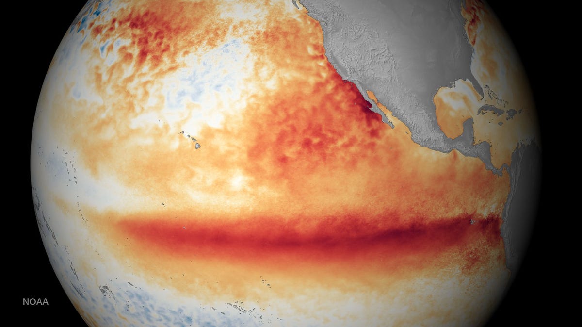
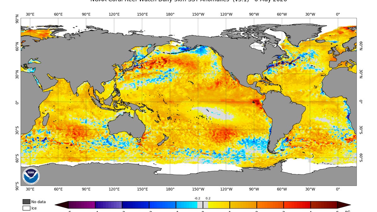
A developing El Niño is showing early signs of influencing weather patterns across the United States.The southern U.S. may see wetter conditions, while the northern U.S. could experience warmer and drier weather.El Niño is expected to lead to a more active hurricane season in the Pacific and a less active one in the Atlantic.Experts are monitoring a "Kelvin wave," a pulse of warm subsurface water that is a key indicator of a strengthening El Niño.A developing El Niño in the Pacific Ocean is showing its earliest atmospheric fingerprints, with scientists detecting shifts in pressure, wind patterns and ocean temperatures that could shape weather across the United States in the months ahead.Experts have warned for months about the potential for a strong or even “super El Niño” as climate models continue to show a pattern that could rival some of the most intense events on record. The latest observations include warmer-than-normal sea surface temperatures and bursts of westerly winds that help push stored heat from the western Pacific toward the central and eastern Pacific.Severe Weather Europe described the transition as a turning point for summer, and potentially, the remainder of this year."The 2026 North American summer season is entering a critical transition phase," Severe Weather Europe wrote. "Latest data confirms that a strong El Niño event is not only developing but is already showing early signs of its presence in the global atmospheric circulation. We are now witnessing the first detectable changes in pressure and temperature patterns across the United States and Canada."If current trends continue, forecasters say the emerging El Niño pattern could influence the jet stream and shift seasonal weather across North America heading into late summer and fall. Those changes could affect rainfall, temperatures and storm tracks in different ways by region.What El Niño could mean for U.S. weather by regionEarly model guidance suggests the developing El Niño may already be nudging atmospheric patterns into a new phase, though impacts remain uncertain this far out. These are the expected impacts each region could expect from El Niño, according to the National Oceanic and Atmospheric Administration.Southern U.S.: A stronger, more active subtropical jet stream that can increase storm systems and rainfall potentialGulf Coast and Florida: Increased rainfall potential, including a higher risk of heavy rain events and localized floodingSouthern tier of the U.S.: A tendency for wetter storm tracks across states from Texas to the SoutheastNorthern U.S. and Pacific Northwest: Warmer and drier conditions, with fewer storm systems tracking through the regionAtlantic basin: Suppressed hurricane activity due to increased wind shear that disrupts storm formationMeteorologists caution that summer impacts are often subtle compared to winter patterns, when El Niño influence is strongest.How will El Niño impact Pacific hurricane season? More storms possibleA developing El Niño in the Pacific Ocean could tilt conditions toward a more active eastern and central Pacific hurricane season this year.That warming signal, if it continues to couple with the atmosphere, can reduce wind shear and support more frequent tropical cyclone development across the basin.AccuWeather expects 17 to 22 named storms in the Eastern Pacific, along with 9 to 13 hurricanes and 4 to 8 major hurricanes this season. The forecast also calls for 6 to 9 direct impacts to Mexico and Central America, more than double the historical average. In the Central Pacific, which includes Hawaii, forecasters are calling for 4 to 7 named storms, 2 to 4 hurricanes and 1 to 3 major hurricanes, with 1 to 2 direct impacts possible for the islands.While California is not typically in the path of tropical systems, forecasters say warmer ocean waters and more favorable storm tracks can increase the risk of tropical moisture reaching the region. That can translate into heavy rainfall and flash flooding in parts of Southern California, particularly in late-season setups.AccuWeather also warns of an elevated flood risk across the broader Southwest, including Arizona and New Mexico, where remnants of Pacific storms can interact with monsoon moisture and produce intense rainfall far inland.The Pacific season began on May 15, and hurricane forecasters are already monitoring two possible tropical storms in the eastern Pacific basin, the National Hurricane Center said in a June 1 advisory.How will El Niño impact Atlantic hurricane season? Fewer storms likelyEl Niño conditions typically suppress Atlantic hurricane activity.The main driver is increased vertical wind shear, or changes in wind speed and direction with height, which can tear apart developing storms before they organize. El Niño also tends to stabilize the atmosphere over parts of the tropical Atlantic, making it harder for thunderstorms to grow into tropical cyclones.As a result, El Niño years often bring fewer named storms, a lower chance of major hurricanes, and reduced development from African easterly waves moving off the coast of Africa.While the overall outlook leans below normal, forecasters caution that impact risk remains significant — particularly in seasons where storms form closer to land or undergo rapid intensification.“People often suffer from a false sense of lead time,” said Ken Graham, National Weather Service Director. “Every Category 5 that’s made landfall in this country was a tropical storm or less at three days out. They rapidly intensify and get here quickly. Preparedness early is absolutely key.”Experts watching 'Kelvin wave': What is it?At the center of the El Niño development is a Kelvin wave — a large pulse of subsurface warm water now rising toward the ocean surface. Think of it as the summer equivalent of the “polar vortex” in winter forecasting: a term that sounds dramatic, but describes a natural, repeating part of the climate system, and is largely just a buzzword.A Kelvin wave is a slow-moving pulse of warm water that travels eastward just below the ocean surface along the equator in the Pacific Ocean, according to NOAA. Unlike surface waves that break at the coast, these are subsurface shifts in ocean heat that move across thousands of miles.They form when changes in wind patterns — especially weaker trade winds or bursts of westerly wind activity — push warm water that has built up in the western Pacific toward the central and eastern Pacific.Kelvin waves generally occur in two phases:Downwelling phase: Warm water is pushed eastward and suppresses colder water from rising to the surface. This can help raise sea surface temperatures in the eastern Pacific and support the early development of El Niño conditions.Upwelling phase: After the wave passes, colder water from below can rise closer to the surface, temporarily cooling the ocean in some areas.According to Severe Weather Europe, it is currently in a downwelling phase, meaning it is actively pushing warm subsurface water eastward across the equatorial Pacific and suppressing cooler water from rising to the surface.A single Kelvin wave can take about two to three months to cross the Pacific, giving forecasters an early signal of how ocean temperatures may evolve.While it does not guarantee an El Niño will develop, strong downwelling waves are often one of the earliest signs that the ocean-atmosphere system is shifting toward warmer conditions.What is ENSO?Short for El Niño-Southern Oscillation, ENSO is the recurring climate pattern that involves the change of temperatures in the central and eastern tropical Pacific Ocean.Every three to seven years, water temperatures across the tropical Pacific Ocean warm or cool by anywhere from 1 to 3 degrees Celsius compared to normal, according to the National Weather Service.What is La Niña?La Niña is a climate pattern that occurs when sea surface temperatures in the central and eastern Pacific Ocean are cooler than average, according to the National Weather Service. This cooling shifts atmospheric circulation, influencing weather around the globe. La Niña can also affect the jet stream, sometimes contributing to polar vortex disruptions that push Arctic air farther south.What is El Niño?El Niño is the opposite pattern, occurring when Pacific Ocean waters in the central and eastern regions are warmer than average, according to NOAA. This warming changes global weather patterns in different ways than La Niña. In the U.S., El Niño winters usually bring wetter, cooler conditions to the southern states and milder, drier weather to the Pacific Northwest.When is the Atlantic hurricane season?The Atlantic hurricane season runs from June 1 through Nov. 30.Ninety-seven percent of tropical cyclone activity occurs during this time period, NOAA said.Stay informed. Get weather alerts via textBrandi D. Addison covers weather across the United States as the Weather Connect Reporter for the USA TODAY Network. She can be reached at baddison@gannett.com. Find her on Facebook here.