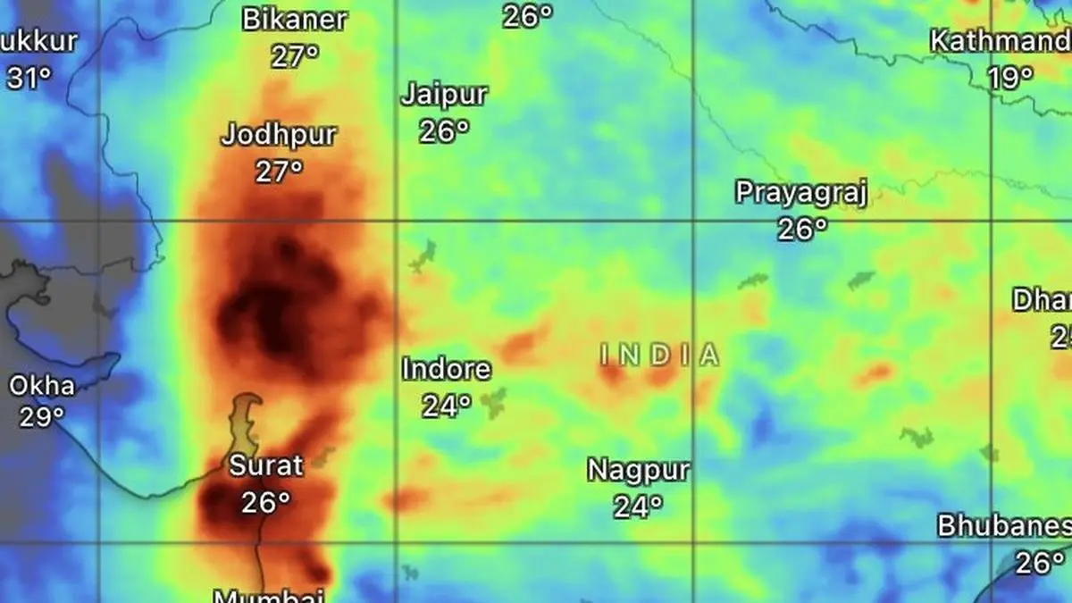
Forecast until Saturday shows heaviest recorded rainfall over south-west Rajasthan, eastern and southern Gujarat, Konkan and Mumbai as the monsoon extents its current vigorous spell.
| Photo Credit:
www.windy.com
The monsoon has sustained fresh momentum across Central, North-West and East India on Wednesday, helping slashing the country’s cumulative rainfall deficit to 21 per cent, even after the low-pressure area that triggered the latest wet spell weakened over land.The improvement was most visible over East and North-East India, where the rainfall shortfall narrowed to 32 per cent. The South Peninsula continued to lag with a 26 per cent deficit, while Central India (13 per cent) and North-West India (18 per cent) emerged as the best-performing regions as widespread rain continued to lash both.Normal rain categoryUnder India Meteorological Department (IMD) norms, seasonal rainfall between 19 per cent below and 19 per cent above the long-period average is classified as normal. That places both Central and North-West India firmly in the normal category, while the South Peninsula and the East and North-Eastern States still face an uphill task to erase their deficits as the season advances.The IMD said the active monsoon phase would persist over the next few days. Eastern Gujarat is likely to receive heavy to very heavy rainfall with isolated extremely heavy falls for next two days, while Madhya Maharashtra is expected to experience similar conditions for another day. The forecast of heavy to very heavy rain also remained in force for Konkan and Goa on Wednesday. Favourable alignmentThe widespread rainfall is being driven by a favourable alignment of monsoon systems. A cyclonic circulation over central north Madhya Pradesh is drawing moisture-laden southwesterly winds from the north Arabian Sea across south Gujarat, Konkan, Mumbai and western Maharashtra. At the same time, the seasonal monsoon trough stretches from Bikaner through Banasthali Vidyapeeth (Rajashtan); Guna and Damoh (Madhya Pradesh); Pendra Road (Chhattisgarh) and Midnapore (West Bengal) before dipping into the north-east Bay of Bengal, maintaining an active monsoon corridor across northern India.Shear zone backStrengthening the system further is an east-west shear zone of monsoon turbulence extending through Porbandar, Bhavnagar, Nandurbar, Nagpur, Raipur, Basna and Bhadrak. Such shear zones are a classic hallmark of an active monsoon, sustaining widespread convection and intense rainfall.Adding to the favourable weather pattern, a western disturbance over Jammu, seen as a cyclonic circulation with an upper-air trough, is interacting with the monsoon flow. The IMD has forecast heavy to very heavy rainfall with isolated extremely heavy falls over Jammu and Kashmir, south-east Rajasthan and south-west Madhya Pradesh on Wednesday.South Gujarat soakedThe active monsoon has already produced exceptional rainfall over parts of western India during the 24 hours ending Wednesday morning. Kaprada (Valsad) recorded 42 cm, followed by Daman (34 cm), Silvassa (33 cm), Daman AWS (32 cm), Chikhli (28 cm), Pardi (26 cm), Vansda (25 cm), Khergam (23 cm) and Madhbun (20 cm) in south Gujarat. Jagalbet in Uttara Kannada received 22 cm.Heavy rainfallHeavy to very heavy rain was also reported from Odisha, Jharkhand, Punjab, Himachal Pradesh, Jammu and Kashmir-Ladakh, East Rajasthan, West and East Madhya Pradesh, Gujarat Region, Konkan & Goa, Madhya Maharashtra and Chhattisgarh.Heavy rainfall extended to parts of Arunachal Pradesh, Assam & Meghalaya, Nagaland, Manipur, Mizoram, Tripura, Sub-Himalayan West Bengal & Sikkim, Gangetic West Bengal, East and West Uttar Pradesh, Uttarakhand, Haryana-Chandigarh-Delhi, Vidarbha, Telangana and Coastal Karnataka, with more widespread rain in store.Published on July 22, 2026