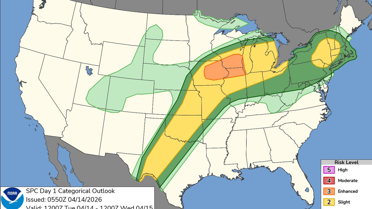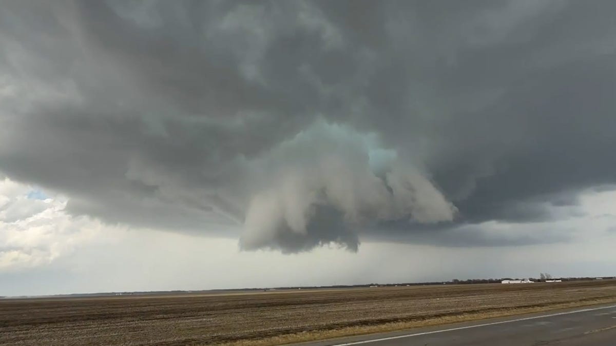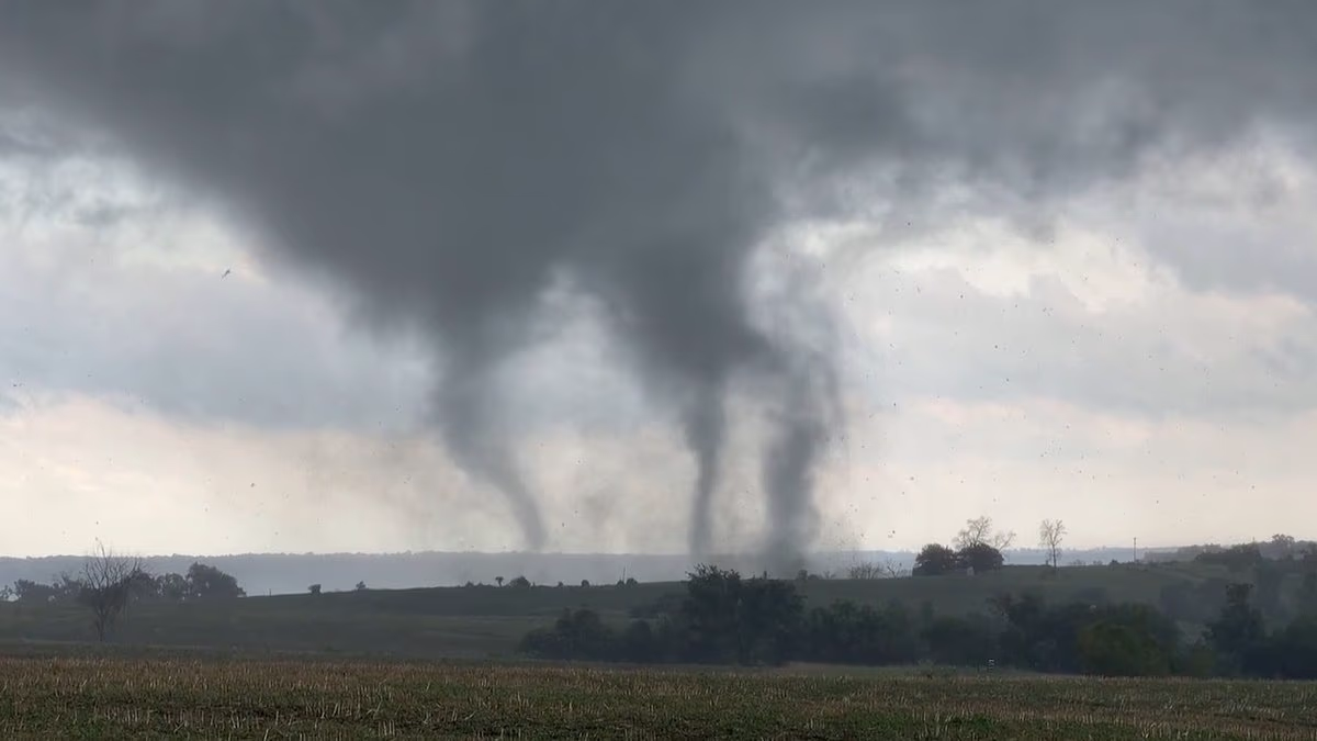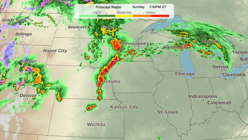
US tornado risk: Meteorologists predict severe thunderstorms across the Northern Plains, with a risk of tornadoes and high winds. Millions of Americans face the risk of severe thunderstorms that may produce tornadoes, large hail, and damaging winds in a matter of hours.US tornado warning: Severe thunderstorms are forecasted for millions in the Northern Plains, with risks of tornadoes, large hail, and damaging winds. (Unsplash)Meteorologists have released hazardous weather forecasts indicating that the conditions are conducive to severe storms in parts of North Dakota, South Dakota, Nebraska, Iowa, and Minnesota.In a social media post on X, Meteorologist Max Velocity stated: “Tornado threat is increasing across the Northern Plains today!”“A few supercells will develop between 3-7pm, producing a risk of giant hail, damaging winds, and a tornado or two. I wouldn't rule out a strong tornado.”Also Read: Bill Pulte net worth: How rich is housing chief? All we know as Trump taps him for acting intelligence chief roleTornado warning: Is driving safe?The most perilous period occurs from approximately 5 PM MDT on Tuesday until 2 AM CDT on Wednesday, as initial high-terrain supercells in eastern Montana and Wyoming coalesce into a structured complex advancing eastward along I-94 and I-90, producing widespread straight-line gusts of 70 to 90 mph.Tornado warning: Here's what one should expectHail: Isolated supercells capable of producing stones of 2 inches or larger early in the eventWind gusts: Localized gusts reaching 90 mph in a straight line once the system organizes overnightTornado risk: Localized but significant risk on Wednesday afternoon near a secondary surface low along the ND/SD borderWorst corridors: I-90 through Rapid City and Wall, I-94 from Miles City to Bismarck and Jamestown, I-25 in eastern Wyoming, and I-29 north of Sioux FallsFlash flooding: WPC Slight Risk (Level 2/4) for North Dakota todayDaytime heating into mid-60s dewpoints is driving CAPE values between 1,500 and 2,500 J/kg, while veering mid-level winds at 40 to 46 mph and effective shear values of 45 to 50 knots maintain updrafts at an angle sufficient to support rotating supercells. A cold front and trailing surface boundaries are supplying the necessary lift.Tornado alerts for North and South DakotaThe Storm Prediction Center has issued a warning indicating that certain regions of North and South Dakota are at a risk of up to 10 percent for a tornado occurring within 25 miles of any specific location on Tuesday, while a larger area throughout the Northern Plains is under a five percent tornado risk.The most immediate danger is present in western and central North Dakota, where the National Weather Service (NWS) has cautioned that storms may generate tornadoes, hail the size of golf balls, and wind gusts reaching up to 70 mph.South Dakota is also poised to experience multiple rounds of severe weather through Thursday.The threat is anticipated to persist on Wednesday, with severe thunderstorms predicted across central North Dakota and extensive areas of South Dakota during the afternoon and evening hours.Will condition worsen after Tuesday?Conditions are anticipated to worsen later on Tuesday throughout central and north-central South Dakota, where the National Weather Service has declared a Level 2 out of 5 severe weather risk.Meteorological authorities are advising residents in the Northern Plains to stay vigilant and ensure they have various means to receive alerts, emphasizing that circumstances can shift quickly once storms start to form.Shweta Kukreti has over 8 years of experience in covering Indian and world politics. She joined the Hindustan Times in 2024 and is primarily assigned to the US desk. She currently works as Deputy Chief Content Producer and reports on a wide range of topics, including US politics, immigration issues (especially H-1B visa) and major global events. Shweta strongly emphasizes team operations, which encompasses monitoring news, delegating tasks, editing, developing comprehensive coverage strategies, and crafting engaging, and data-informed narratives. She received the Digi Star Award at the Hindustan Times within a year of joining for her broad coverage of US politics. In 2025, she earned both a promotion and a redesignation, a significant achievement recognising her contributions and the strong value she brings to the team. She has previously worked with the Indian Express, HTDS, ANI and Republic World. Seniors in all the media organisations recognised her work. Regarding education, she earned a BA (Hons.) in Political Science and a master's degree from Delhi University, and she pursued a PG Diploma in English Journalism from the Indian Institution of Mass Communication (IIMC). She also holds a diploma in Women's Empowerment and Development from IGNOU University and a French certification course from Alliance Française de Delhi. If not working, you can find her exploring the hills and engaging in adventurous activities in Rishikesh and Himachal Pradesh. She loves to play badminton, volleyball, and chess, and spend time with her friends and family. She also enjoys spiritual activities.Read MoreSee Less
Tornado risk threatens 5 US states: Check map as hazardous weather warning issued, know what to expect
US tornado risk: Meteorologists predict severe thunderstorms across the Northern Plains, with a risk of tornadoes and high winds.
795 words~4 min read