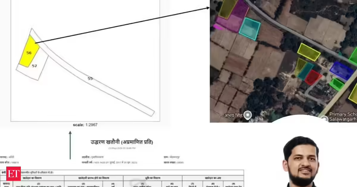
A man has gone viral online after revealing how an AI assistant helped him locate 25 pieces of ancestral land in Uttar Pradesh’s Mohammadpur village, land he could not identify on his own despite being the legal heir. The unusual story, shared by Zahid Khan on LinkedIn, has sparked conversations around how artificial intelligence may solve everyday problems hidden inside India’s complicated government systems.Family land lost in paperwork mazeIn his post, Khan explained that the land had passed down through several generations — from his great-grandfather to his grandfather, then to his father, and eventually to him. But finding the actual plots turned into a difficult task because the records were scattered across different government websites and written in highly technical Hindi.“The land records are digitized, but spread across multiple government websites, all in dense official Hindi that's genuinely hard to parse even if you can read the language. The kind of Hindi that makes legal documents feel like ancient scripture,” he explained.Khan said he had visited Mohammadpur only a few times in his life and had no practical way to identify the exact locations of the family property.AI assistant searched records and decoded mapsTo solve the problem, Khan turned to Anthropic’s Claude AI assistant and used its “computer use” feature. According to him, the AI navigated through government land record portals, entered his late father’s name in Hindi using an on-screen keyboard, and searched family-linked property details.The assistant reportedly identified all related plots and extracted the official Gata Sankhya numbers linked to 25 separate land parcels.The process became more technical when the AI encountered state mapping databases using Universal Transverse Mercator (UTM) coordinates instead of normal latitude and longitude formats. Khan said the AI then suggested a custom “shift-click tool” to pull polygon data from the plots.After converting the coordinates, the assistant created a KML mapping file and uploaded it to Google My Maps. The final output showed clear property boundaries and GPS-routable locations for the ancestral land.Viral post triggers debate on practical AI useKhan said the AI-driven method removed the need to manually search old paperwork or depend on local middlemen to identify the land.His post quickly gained attention online, with many users describing it as one of the most meaningful examples of artificial intelligence solving a deeply personal and real-world problem.One user wrote, “This is among the few real use cases I've come across for AI use, which is super encouraging. This should be augmented as an agent into the Govt. Registrar of Property website.”Another commented, “Fascinating use case, AI bridging language and bureaucracy to reconnect families with their roots." Shows how tooling can turn archival data into personal stories."A third user added, “This is so cool! India definitely has massive amounts of digitised yet still unusable data. AI agents navigating these kinds of government workflows may unlock enormous value over the next few years.”
UP man uses AI to trace lost 25 ancestral land plots in village he barely knew, here's how he did it
An AI assistant has helped Zahid Khan find 25 ancestral land parcels in Uttar Pradesh's Mohammadpur village. The land records were scattered and in technical Hindi. Khan used an AI tool to navigate government portals and decode maps. This innovative use of AI is reconnecting families with their heritage. It highlights AI's potential to simplify complex government systems.
478 words~2 min read