Show Caption
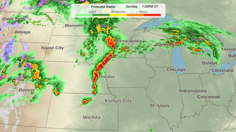
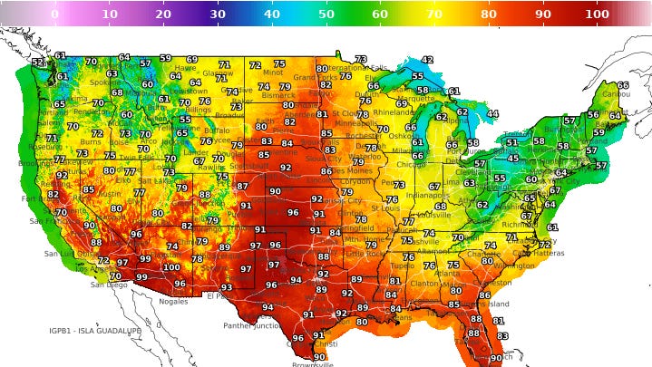
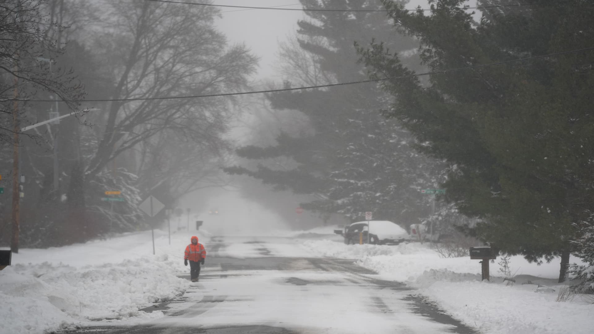
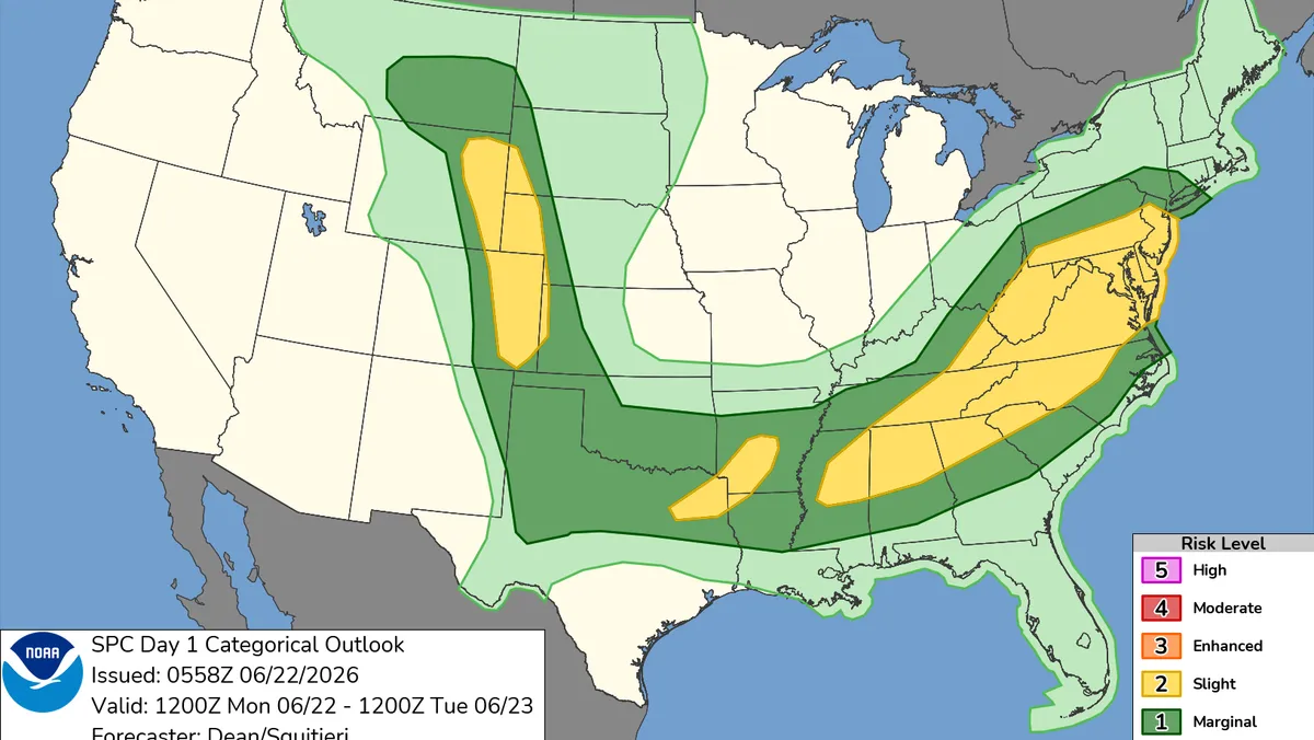
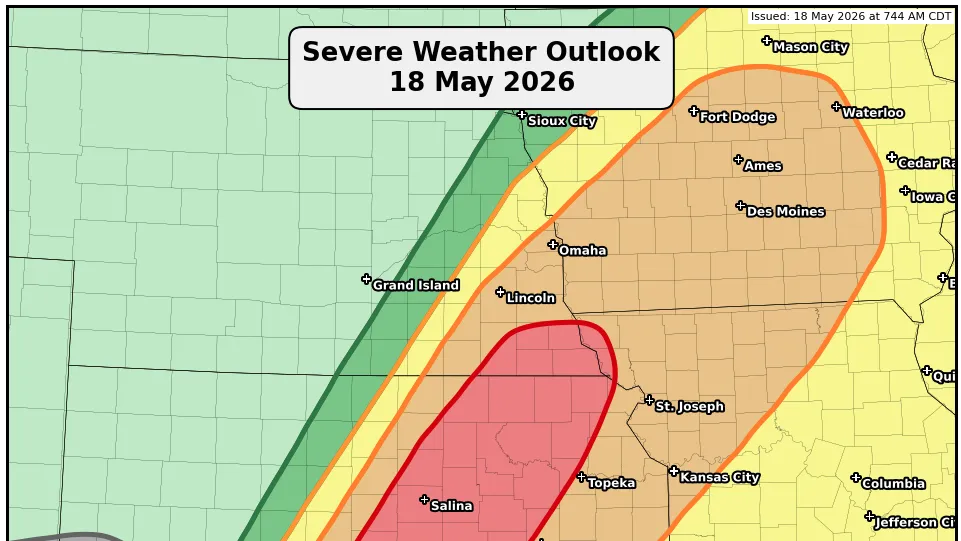
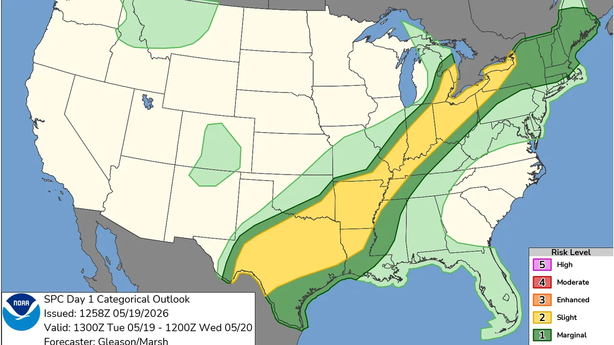
A chaotic weather pattern is causing severe storms in some U.S. regions and an early heat wave in others.Millions from Texas to the Ohio Valley face threats of damaging winds, large hail, and flash flooding.Record-challenging temperatures in the 90s are impacting much of the eastern U.S. due to a large Atlantic weather system.A slow-moving cold front is expected to bring cooler air to the East while continuing to fuel storms in Texas.A sprawling and chaotic weather pattern is sweeping across the United States this week — bringing severe storms and flash flooding to some regions while others bake under an early-season heat wave.Forecasters warned Tuesday that millions of people from Texas to the Midwest and Ohio Valley could see severe thunderstorms capable of damaging winds, large hail and heavy rainfall through the night.At the same time, temperatures climbing into the 90s are challenging records across much of the eastern U.S., including cities along the I-95 corridor and parts of New England.The sharp contrast has created a weather map that looks more like midsummer in some places and early spring in others.“An early-season heatwave is in full swing across the eastern U.S.,” the Weather Prediction Center said Tuesday.Where severe storms are expectedThe Storm Prediction Center placed portions of Texas, Oklahoma, the lower Mississippi Valley, Ohio Valley and lower Great Lakes under a slight risk for severe thunderstorms Tuesday as multiple rounds of storms develop along a slow-moving cold front.Forecasters said the primary threats include damaging wind gusts, large hail and localized flash flooding from repeated rounds of heavy rain. While tornadoes are not expected to be the main concern, a few stronger storms could still become intense.West-central Texas could see the greatest hail threat Tuesday afternoon and evening, where atmospheric conditions may support isolated supercells capable of producing hail larger than 2 inches in diameter.Heavy rainfall may also lead to flash flooding concerns across parts of central and eastern Texas, as well as portions of the Midwest and Ohio Valley, especially in areas that see storms repeatedly track over the same locations.Storms developing across the southern Plains later Tuesday could continue overnight and gradually push toward the Texas and Louisiana coasts before weakening early Wednesday.Why the East Coast is so hotA large weather system parked over the western Atlantic is funneling warm, humid air northward across much of the eastern half of the country."A Bermuda High anchored over the western Atlantic will continue to bring a long fetch of warm southerly flow across the eastern half of the country, with high temperatures reaching into the mid-90s during the next couple of days," the Weather Prediction Center wrote. "These temperatures will challenge or break temperature records across the east-central U.S. including the Mid-Atlantic, spreading into New England this afternoon."The Weather Prediction Center said widespread moderate to major HeatRisk levels are expected across several large metro areas Tuesday, including cities along the East Coast and into upstate New York.Meanwhile, some colder areas behind the same weather system saw frost and freeze alerts Tuesday morning across parts of the northern Plains and Rockies following late-season snowfall.What happens nextThe cold front responsible for much of Tuesday’s storm activity is expected to continue sliding east on Wednesday before slowing and stalling over Texas later in the week, according to the Weather Prediction Center. As it moves through, it will gradually bring cooler air into parts of the eastern U.S., easing the early-season heat wave in some areas.At the same time, rounds of showers and thunderstorms are expected to continue developing along and ahead of the front, with Texas remaining a focal point for heavier rain and repeated storm activity.Farther north, additional storms could stretch from the Plains into the Midwest and Northeast as the system lingers.Elsewhere, mountain snow showers may persist in parts of Colorado, while increased moisture near the Bahamas could support a rise in thunderstorm activity across Florida later this week.The end result is a split-weather pattern across the country — with winter-like conditions in some western areas, summer-like heat in the East and active storm tracks in between.U.S. weather watches and warningsStay informed. Get weather alerts via textBrandi D. Addison covers weather across the United States as the Weather Connect Reporter for the USA TODAY Network. She can be reached at baddison@gannett.com. Find her on Facebook here.