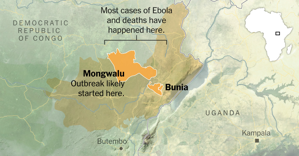
Successful outbreak response depends on seeing what is happening, reaching affected populations and delivering timely support. In eastern Democratic Republic of the Congo (DRC) those seemingly straightforward objectives become extraordinarily difficult. Armed conflict, population displacement, informal border crossings, mining activity and limited transportation infrastructure create an environment where information is often incomplete and access can change overnight. When responders cannot see what is happening, they cannot make the best decisions.This is where Earth observation has become an increasingly important part of the public health toolkit. Satellite imagery, environmental monitoring, mobility data and geospatial analysis cannot replace epidemiological surveillance or the expertise of local health professionals. They can, however, provide an independent and continually updated picture of conditions on the ground, helping responders make decisions when traditional information is delayed or unavailable.Long before an outbreak begins, Earth observation can improve preparedness. Monitoring changes in forest cover, habitat suitability, land use and human encroachment helps identify places where people, wildlife and environmental disturbance increasingly intersect. These are the landscapes where surveillance and prevention efforts can be focused before a crisis emerges.Once an outbreak occurs, those same technologies become operational tools. High-resolution satellite imagery can identify settlements, roads, mining sites, health facilities, forest disturbance and population distribution in areas that may otherwise remain poorly mapped. Combined with epidemiological information, these data help responders understand not only where disease exists, but the environmental and social conditions that influence how it may spread.Conflict adds another layer of complexity. In North Kivu and Ituri insecurity has repeatedly disrupted health care delivery and displaced communities. Satellite imagery from Mongbwalu documented changes to temporary medical facilities after an attack, providing objective evidence of operational disruption where direct reporting was constrained. Human mobility data complements this picture by revealing how communities are connected and where movement may create opportunities for transmission. Accessibility models built from roads, rivers, elevation and land cover help estimate travel times to treatment centres and identify populations that are underserved.Individually, each of these datasets offers only a partial view. Together they create something much more valuable: a shared operating picture that allows responders to understand disease dynamics and the practical realities of delivering care.That integration is the real opportunity. The goal is not another stand-alone map or dashboard, but a public health intelligence system that combines Earth observation, epidemiological surveillance, conflict information, mobility analysis, accessibility modelling and local knowledge into a common decision support framework. Servir demonstrates how Earth observation, artificial intelligence and regional partnerships can provide the scientific backbone for this kind of integrated approach.From an emergency management perspective, actionable intelligence only matters when it informs operational decisions. During Liberia’s 2014–2016 Ebola epidemic, and today supporting preparedness and response in South Sudan, timely geospatial intelligence can strengthen surveillance, prioritise resources, guide field operations and accelerate co-ordinated action before outbreaks outpace response capacity.However, technology is only part of the solution. Lasting success depends on partnerships with regional institutions, governments, researchers, health professionals and communities. These systems must be built with local partners, supported by trust and shared ownership, so they continue to strengthen preparedness long after a single outbreak has ended. We learnt the hard lesson during the 2018-2020 DRC Ebola outbreak that effective containment was not driven by clinical infrastructure alone, but by people and organisations with deep pre-existing relations with local communities that could be mobilised to change behaviours around caregiving, burial practices and health-seeking.Earth observation data has also proved useful in understanding the origins of Ebola outbreaks. Such data has shown Ebola virus outbreaks are more common in areas of forest fragmentation, and helped to assess the origin of a devastating outbreak among non-human primates. Similar data was used to show the emergence of Ebola viruses as human pathogens, and their dispersal to new landscapes, are associated with land use change.The lessons from eastern DRC extend well beyond Ebola. As climate change, ecological disruption, conflict and human mobility increasingly shape global health risks, our ability to integrate diverse sources of information into timely, actionable intelligence will become as important as the individual technologies themselves. The better we can see the landscape in which outbreaks unfold, the better prepared we will be to protect the communities living within it.Saah is a professor and director of the Geospatial Analysis Lab at the University of San Francisco; Kaileh, a research associate in geospatial science and environmental health at Spatial Informatics Group; Cohen is an adjunct assistant professor at the Uniformed Services University of Health Sciences and a primary care physician; Nyenswah, the inaugural director of the Centre for Public Health Emergency Management at the Africa CDC; and James is a professor and senior adviser at the Pandemic Centre in the School of Public Health and director of the Africa Initiative at Brown University.Business Day
Geospatial tools help track Ebola and prevent spread
Integrated data systems help responders reach vulnerable populations despite conflict and limited access
789 words~4 min read