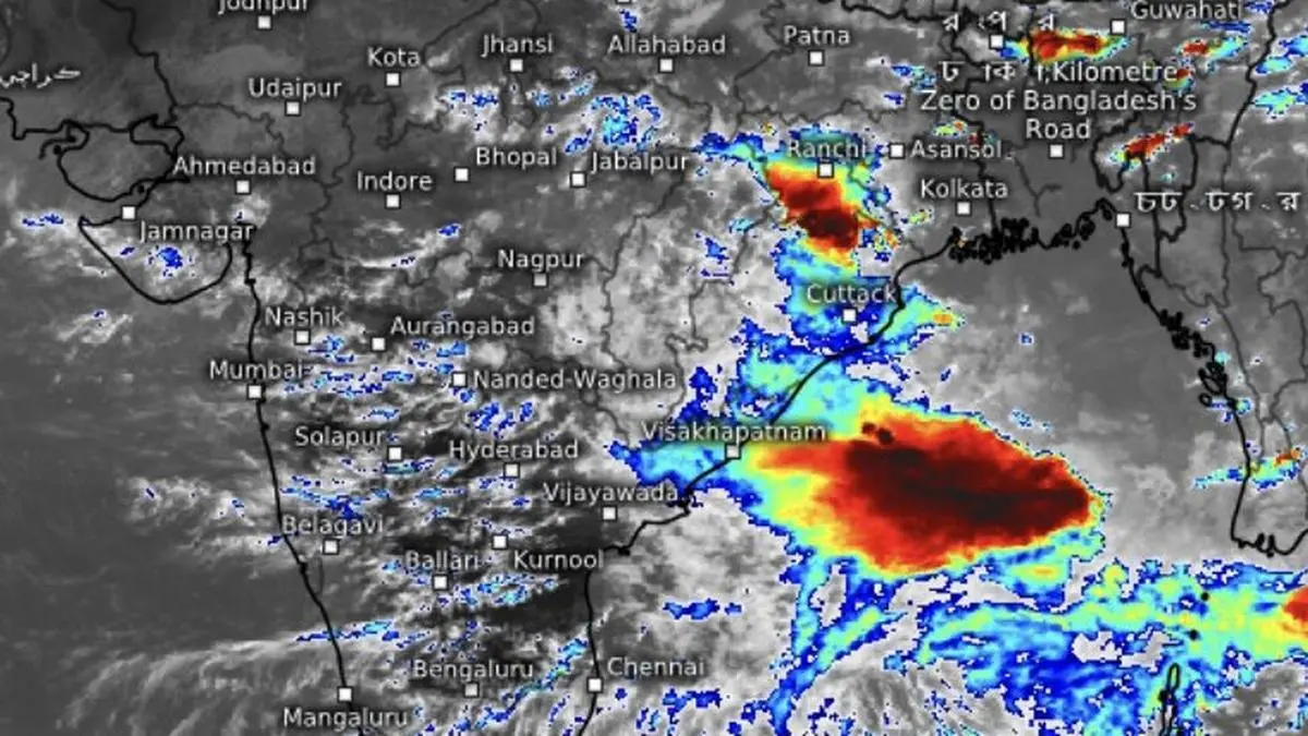
A brewing low-pressure area on Tuesday, only the second of the season, is bringing back monsoon clouds and heavy rain (in dark red) off the Andhra Pradesh coast in what is expected to be a revival phase.
| Photo Credit:
wwwmeteologix.com/in
A fresh low-pressure area, only the second of the season, is set to form over the north Bay of Bengal and the adjoining West Bengal-Bangladesh coast by Tuesday, the India Meteorological Department (IMD) said on Monday. The system is expected to revive the monsoon after its current weak phase, which has closely resembled a break-monsoon situation, though it has not been officially declared as one.Rainfall retreatsDuring this weak spell, rainfall has largely retreated from most parts of the country, persisting mainly over East and North-East India and stretches of the east coast, including Odisha, Andhra Pradesh and Tamil Nadu. Ironically, this “break-like” phase is itself nearing an end. An upper-air cyclonic circulation has already formed over the north Bay and adjoining south Bangladesh, a favourable location for spawning a low-pressure system. While the circulation has so far channelled rainfall mainly into East and North-East India, the anticipated ‘low’ is expected to broaden the reach of the monsoon.Trough bends to seaAnother sign of revival came from the seasonal monsoon trough, the atmospheric spine of the monsoon. On Monday, it extended from Jammu through Dehradun (Uttarakhand), Barabanki (Uttar Pradesh), Patna (Bihar), Bankura and Canning (West Bengal), before dipping into the east-central Bay. Over the past several days, the eastern end of the trough has remained over the plains and locked against the Himalayan foothills, a classic indicator of a weak monsoon over much of India, when the trough too had aligned in tandem.. West Pacific churnIts southward shift back over the Bay, coupled with the formation of a low, is expected to restore monsoon activity across wider areas. How far the revival spreads, however, will depend on the strength, track, intensity and lifespan of the emerging low-pressure system.The Bay system owes its origins to weather disturbances over the western Pacific. Typhoon Bavi, which crossed southern China after skirting Taiwan, has since moved towards the Korean Peninsula, and helped energise the region. Another tropical storm, Haishen, was active east of the Philippines on Monday, continuing the chain of disturbances that often seed monsoon systems over the Bay.Rain deficit growsMeanwhile, the prolonged weak phase has widened rainfall deficits in parts of the country. The South Peninsula now has a 22 per cent deficit and Central India 8 per cent, reversing gains made during last week’s heavy rains. Marathwada, Vidarbha, Madhya Maharashtra, and Saurashtra and Kutch have again slipped into deficit.North-West India has a rainfall deficit of 12 per cent, with East Uttar Pradesh and Punjab faring the worst. East and North-East India remain the most rain-deficient regions at 36 per cent, although this marks an improvement from 42 per cent a week ago. The all-India deficit stands at 19 per cent, still within the IMD’s normal range. With the ‘low’ expected to deepen and move inland, the coming days could bring relief to several rain-starved regions. Published on July 14, 2026