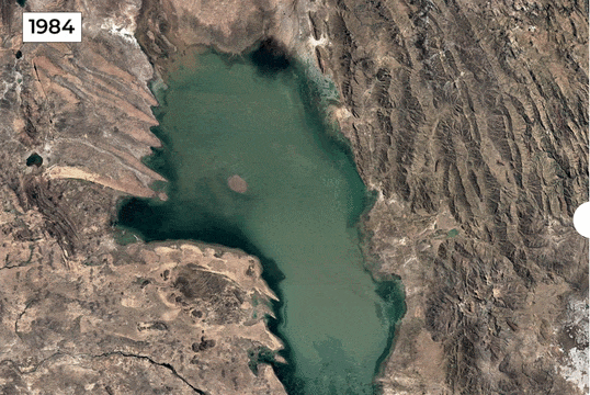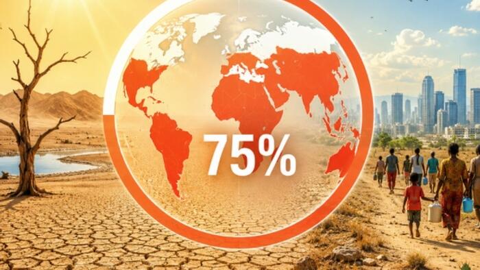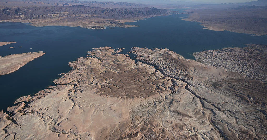
Across the planet, rivers, lakes, and reservoirs that once supported millions of people are shrinking at an alarming rate.New satellite comparisons reveal how climate pressure, drought, and human activity are transforming some of Earth’s most important freshwater sources. From South America to Africa, disappearing water bodies are exposing a growing global challenge: the loss of freshwater, as per a report by Al Jazeera.Across continents, water bodies that once supported communities, agriculture, wildlife, and economies are shrinking under pressure from prolonged droughts, rising temperatures, and growing demands on natural resources.You Might Also Like:The world is losing an estimated 324 trillion litres (85.6 trillion gallons) of freshwater every year, enough to meet the needs of 280 million people annually, according to a 2025 World Bank report.This continuing decline is known as “continental drying,” a process linked to worsening drought conditions and unsustainable land and water practices. To highlight the issue, the UN observes June 17 as the World Day to Combat Desertification and Drought, encouraging efforts to restore damaged land and protect water resources, as per a report by Al Jazeera.Al Jazeera examined satellite images of 10 locations around the world where lakes, rivers, and wetlands have dramatically changed.What Is Happening To The World’s Water Sources?You Might Also Like:One of the clearest examples can be seen in the Parana River in South America. Stretching around 4,900km (3,030 miles), it is the continent’s second-longest river after the Amazon and a crucial trade route connecting Brazil, Paraguay, and Argentina.Satellite comparisons between 1990 and 2026 show a major drop in water levels near the port of Rosario. Years of drought have exposed large sections of riverbed, created new islands, disrupted grain transportation, and affected hydroelectric production at the Itaipu Dam.In Bolivia, Lake Poopó has become one of the most striking examples of a disappearing lake. Once the country’s second-largest lake, covering around 1,000 square kilometres (390 square miles), it has almost completely vanished.Images from 1984 and 2020 show how drought, water diversion, and warming temperatures transformed the lake into a salt flat. The disappearance damaged fishing communities and affected the Indigenous Uru people who depended on the lake.You Might Also Like:Which Major Lakes And Rivers Are Shrinking?In Botswana, Lake Ngami has experienced dramatic changes over time. Located near the Okavango Delta, the lake depends on water flowing from the surrounding system.Satellite images from 1984 and 2020 show how drought and changing inflows pushed the lake close to disappearing. Productive fishing areas and grazing lands turned into a dry, cracked landscape before some recovery occurred.Chile’s Laguna de Aculeo tells a similar story. Once a popular recreational destination near Santiago, the lagoon has largely disappeared after years of drought and water stress. A comparison between 2007 and 2026 shows the scale of the transformation.Iran’s Lake Urmia has also suffered a severe decline. Once the Middle East’s largest saltwater lake, it covered nearly 6,000 square kilometres (2,300 square miles) during the 1990s. It has since fallen to around 581 square kilometres (224 square miles), leaving huge areas as exposed salt flats.The causes include repeated droughts, agricultural water use, river diversion, and groundwater extraction.The al-Chibayish Marshes in Iraq have faced similar challenges. Part of the Mesopotamian Wetlands, a UNESCO World Heritage Site, the marshes were heavily affected by drainage and drought during the 1990s. However, some areas have shown recovery in recent years due to increased rainfall and restoration work.Why Is Freshwater Loss Becoming a Global Concern?In Madagascar, the town of Ambovombe has experienced severe climate stress. Southern Madagascar has faced repeated droughts and rising temperatures, damaging farmland, reducing water availability, and affecting communities that depend on agriculture and livestock.Lake Faguibine in Mali has also nearly disappeared. Historically filled by floodwaters from the Niger River, the lake has shrunk due to reduced flooding, drought, and sediment buildup. Much of its former basin has become dry and increasingly desertified.In the United States, Lake Mead has experienced a major decline. The reservoir, created by the Hoover Dam on the Colorado River, supplies water to millions of people across the US Southwest and parts of Mexico.Satellite images from 1984 and 2020 show how drought, warming temperatures, and heavy water demand lowered water levels and exposed previously submerged areas.Perhaps one of the most famous examples is the South Aral Sea in Uzbekistan. Once one of the world’s largest lakes, it has shrunk by more than 90 percent due to decades of river diversion for irrigation.The disappearance of the Aral Sea is considered one of the world’s worst human-caused environmental disasters, leaving behind a vast exposed lakebed.These satellite images reveal a common pattern: freshwater systems around the world are under growing pressure. The shrinking of rivers, lakes, and wetlands shows how climate change and human activity are reshaping the planet’s water supply.Protecting these resources has become essential as communities worldwide face increasing challenges from drought and water scarcity.FAQWhy is freshwater disappearing?Due to drought and human pressure.Which places are affected?Lakes, rivers, and reservoirs worldwide.You Might Also Like:
Are the world’s freshwater sources vanishing before our eyes? Satellite images reveal an appalling global water crisis
Global freshwater sources are alarmingly diminishing, with satellite images revealing 10 critical locations experiencing severe water loss. From South America's Parana River to Uzbekistan's Aral Sea, continental drying, driven by climate change and unsustainable practices, is impacting millions and threatening ecosystems. This urgent crisis demands immediate attention and action.
822 words~4 min read