June 2, 2026 | 06:58 am
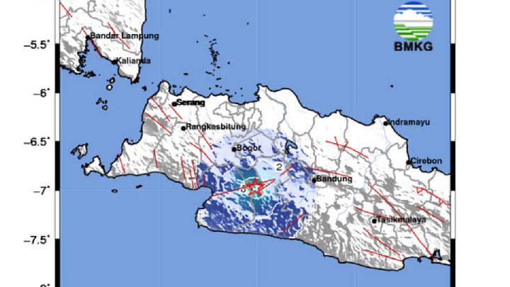
TEMPO.CO, Jakarta - The Indonesian Meteorology, Climatology, and Geophysics Agency (BMKG) recorded 136 earthquakes throughout May 2026 in the West Java region. Eleven of them were felt by residents in the Priangan Timur and Sukabumi areas.The Acting Head of BMKG Bandung's Geophysics Station, Edi Wibowo, stated that the majority of earthquakes that occurred were shallow, with a depth of less than 60 kilometers, totaling 121 times, while earthquakes with a medium depth of 60-300 kilometers occurred 15 times."As for the magnitude, the largest recorded earthquake was 4.6 and the smallest magnitude was 0.8," Edi said in his statement on Monday, June 1, 2026. Based on the earthquake epicenter, 65 earthquakes were centered in the southern Indian Ocean of Java, and 71 earthquakes on land.Among the eleven felt earthquakes, the strongest tectonic earthquake with a magnitude of 4.7, based on data updates, shook the Tasikmalaya, Garut, Ciamis, and surrounding areas on Thursday, May 21, 2026, at 04:04 AM local time.Based on reports from the public, the earthquake tremors felt in the Tasikmalaya and Garut areas were distinctly felt inside houses, as if there were passing trucks or at an intensity scale of III MMI. Meanwhile, in the Ciamis area, the tremors varied around II-III MMI, and some residents felt it inside their homes, causing light hanging objects to sway."Up to now, there have been no reports of building damage as a result of the earthquake," said the Head of BBMKG Region II Tangerang, Hartanto, in his statement after the earthquake.Based on BMKG's analysis, the earthquake epicenter was located at coordinates 8.27 degrees South Latitude and 108.25 degrees East Longitude, or in the sea at a distance of 68 kilometers southwest of Pangandaran Regency. The earthquake was classified as shallow at a depth of 21 kilometers. "Due to the activity of underwater active faults," he said.Earthquake tremors were also felt in the Sukabumi area and its surroundings with a magnitude of 2.6 on Tuesday, May 19, 2026, at 5:50 PM local time. According to BMKG, the latest earthquake epicenter in Sukabumi was located at coordinates 6.88 degrees South Latitude and 106.81 degrees East Longitude. "Located on land at a distance of 13 kilometers northwest of the city of Sukabumi," said Hartanto in his statement on Tuesday, May 19, 2026Prior to this, on Sunday, May 17 at 10:15 PM local time, the Sukabumi Regency and its surroundings were struck by a tectonic earthquake with a magnitude of 4.7. The earthquake epicenter was located at coordinates 7.53 degrees South Latitude and 106.72 degrees East Longitude. Specifically located in the sea at a distance of 63 kilometers southeast of Sukabumi Regency. The earthquake was classified as shallow at a depth of 28 kilometers due to the activity of underwater active faults.Based on reports from the public, the earthquake was widely felt in the Palabuhanratu, Cisolok, Cibadak, Cisaat, Cidahu, Cicantayan, Nagrak, Ciwidey, Nyalindung, Lengkong, Parungkuda, Caringin, Kota Sukabumi, Cianjur, with an intensity scale of II MMI. The earthquake tremors were felt by some people and caused light hanging objects to sway.Meanwhile, in the Cidolog, Cidadap, Pabuaran, Surade, Ciracap, Ciemas, Jampang Kulon, earthquake tremors were felt up to Intensity Scale III MMI, felt inside houses as if there were passing trucks.Read: BMKG Reports Strengthening Australian Monsoon in Recent DaysClick here to get the latest news updates from Tempo on Google News