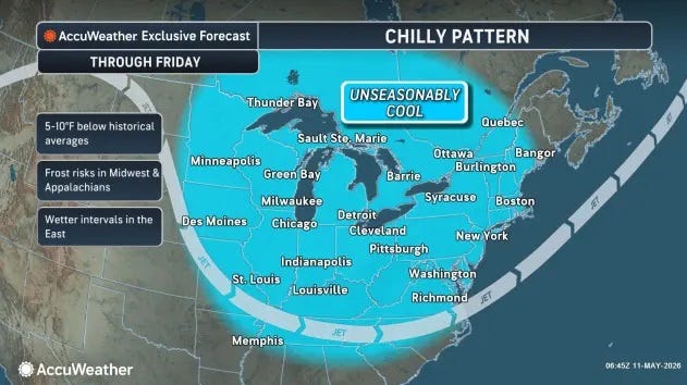
Another cold front sweeping down from Canada will drop already moderate temperatures 10-20 degrees across parts of the Midwest this week before its grip spreads across the Northeast, forecasters say.
"Temperatures will be stuck in the upper 60s, even lower 60s for much of the Midwest through next weekend," AccuWeather Senior Meteorologist Tyler Roys told USA TODAY. "This front is largely going to slowly take its time moving across to New England. It's going to feel like late September, early October for some places later this week."
Chicago's high temperature for Sept. 3 was forecast at 76 degrees. The high Sept. 4-6 will only reach 66 degrees, the National Weather Service says. Detroit could see 84 degrees Sept. 3 while the high for Sept. 4-7 will only reach the upper 60s. Grand Forks, North Dakota, is among cities where the high Sept. 4-5 is forecast in the 50s.
Roys credited an upper level low system that will be rolling in from Canada. The front will move across the Upper Midwest on Sept. 2 and across the Great Lakes and into the Ohio Valley on Sept. 3. As it approaches the East Coast it will slow down.
"Especially in the D.C. area, the Philadelphia area, it will be moving at a snails pace," Roys said. "Those areas will get a taste of what summer used to be before the front is knocking on your door Thursday, slowly moving in Friday and sneaking through on Saturday."